


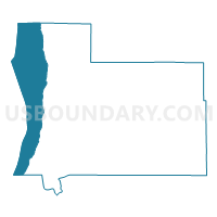
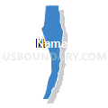
Voting Districts not defined, Antrim County, Michigan
About
Outline

Summary
| Unique Area Identifier | 595852 |
| Name | Voting Districts not defined |
| County | Antrim County |
| State | Michigan |
| Area (square miles) | 76.77 |
| Land Area (square miles) | 0.00 |
| Water Area (square miles) | 76.77 |
| % of Land Area | 0.00 |
| % of Water Area | 100.00 |
| Latitude of the Internal Point | 45.06398170 |
| Longtitude of the Internal Point | -85.41856010 |
Maps

Graphs
Select a template below for downloading or customizing gragh for Voting Districts not defined, Antrim County, Michigan


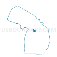
Neighbors
Neighoring Voting District (by Name) Neighboring Voting District on the Map
- Voting District 0090524000001, Antrim County, MI
- Voting District 0092534000001, Antrim County, MI
- Voting District 0095444000001, Antrim County, MI
- Voting District 0098010000001, Antrim County, MI
- Voting District 0295934000011, Charlevoix County, MI
- Voting District 0550020000001, Grand Traverse County, MI
- Voting Districts not defined, Grand Traverse County, MI
- Voting Districts not defined, Leelanau County, MI
- Voting Districts not defined, Charlevoix County, MI
Top 10 Neighboring County Subdivision (by Population) Neighboring County Subdivision on the Map
- Acme township, Grand Traverse County, MI (4,375)
- Elk Rapids township, Antrim County, MI (2,631)
- Milton township, Antrim County, MI (2,204)
- Banks township, Antrim County, MI (1,609)
- Torch Lake township, Antrim County, MI (1,194)
- Norwood township, Charlevoix County, MI (723)
- County subdivisions not defined, Charlevoix County, MI (0)
- County subdivisions not defined, Grand Traverse County, MI (0)
- County subdivisions not defined, Antrim County, MI (0)
- County subdivisions not defined, Leelanau County, MI (0)
Top 10 Neighboring Place (by Population) Neighboring Place on the Map
Top 10 Neighboring Unified School District (by Population) Neighboring Unified School District on the Map
- Traverse City Area Public Schools, MI (79,692)
- Elk Rapids Schools, MI (8,621)
- Charlevoix Public Schools, MI (8,573)
- Central Lake Public Schools, MI (3,286)
- Northport Public School District, MI (2,000)
- Ellsworth Community Schools, MI (1,585)
- Beaver Island Community School, MI (657)
- School District Not Defined (Water), MI (243)
Top 10 Neighboring State Legislative District Lower Chamber (by Population) Neighboring State Legislative District Lower Chamber on the Map
- State House District 104, MI (104,139)
- State House District 105, MI (95,524)
- State House District 101, MI (92,671)
Top 10 Neighboring State Legislative District Upper Chamber (by Population) Neighboring State Legislative District Upper Chamber on the Map
Top 10 Neighboring 111th Congressional District (by Population) Neighboring 111th Congressional District on the Map
Top 10 Neighboring Census Tract (by Population) Neighboring Census Tract on the Map
- Census Tract 9606, Antrim County, MI (3,290)
- Census Tract 5501.02, Grand Traverse County, MI (2,956)
- Census Tract 8, Charlevoix County, MI (2,928)
- Census Tract 9601, Antrim County, MI (2,602)
- Census Tract 9900, Antrim County, MI (0)
- Census Tract 9900, Leelanau County, MI (0)
- Census Tract 9900, Grand Traverse County, MI (0)
- Census Tract 9900, Charlevoix County, MI (0)
Top 10 Neighboring 5-Digit ZIP Code Tabulation Area (by Population) Neighboring 5-Digit ZIP Code Tabulation Area on the Map
- 49720, MI (9,172)
- 49690, MI (6,182)
- 49629, MI (2,223)
- 49648, MI (2,098)
- 49729, MI (1,446)
- 49627, MI (206)